
Geoida
Help
|
|
Geoida |
Digitise Provisional Points |
Use this option to quickly create new points by clicking their approximate positions on-screen - a new point's details are immediately displayed in the Digitise Point window (same as the Interrogate Point window) for acceptance or further editing before saving.
It is particularly useful to use this option to create new points with approximate provisional coordinates for least squares network adjustment - once the fixed control points in a network have been defined (eg, in Enter Points), the un-fixed observed points may be coordinated approximately using this option, provided that they retain their correct positional relationships to one-another.
This option can also be used as a means of entering a small number of new points into the database as an alternative to the Enter Points option.
When the Digitise Provisional Points option is selected, the prompt Position cursor for required point appears in the status bar prompt-panel - place the cross-hair pointer at the position required for the new point and click the mouse to create the point at that position. Note that unless zoomed at a large scale, it will not usually be possible to accurately set the coordinates due to the finite screen resolution - to achieve an accurate position it may then be necessary to further edit the coordinates once the Digitise Point window is displayed.
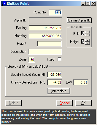
The Digitise Point window displays the details for the new point.
|
|
More Info: |
When Geoida is running, details of the purpose and use of each control in this window will be displayed in the bottom panel when the mouse is passed over any active object. |
The point number field will initially be blank for the new point so that a point number can be allocated - it is not possible to save a new point if no point number is allocated, and the new number cannot be the same as that of an existing point.
The Interpolate button will be enabled if a geoid model exists, and an approximate geoid-spheroid separation value may thus be interpolated based on the point's approximate horizontal position. If the point's horizontal position is to be later adjusted by (eg) least squares, the geoid-spheroid separation will also be re-valued based on it's new adjusted position.
Click OK to save, or Cancel to discard, any changes made to the selected point - the cross-hair pointer will re-appear to position another point as prompted. When Digitise Provisional Point is no longer required, press the keyboard Escape button or the right mouse button to close the option; selecting another menu item will also terminate this option.
For additional details concerning editing individual points, refer to Interrogate Point.
| Converted from CHM to HTML with chm2web Standard 2.85 (unicode) |