
Geoida
Help
|
|
Geoida |
Traverse |
The Traverse option may be used to enter and compute either simple traverses, or horizontal and/or vertical networks, in a variety of data combinations.
The number of observations in a traverse or network that may be computed in one processing run is limited only by the amount of computer memory available.
Observation data may be entered in a wide variety of combinations and may consist of only a minimum of information (eg horizontal angle / bearing and horizontal distance only), or may be entered in such combinations as horizontal distance and vertical component, slope distance and vertical angle, or slope distance and heights, all combined with any other data such as instrument and prism heights, reverse observations, etc; observations for levelling networks may also be entered. The data may also consist of multiple (repeated) observations at any instrument station.
Important details about the conventions used to enter and distinguish different observation types may be found at Observation Conventions and Types for Traverse and Network
Up to 99 different compilations of traverse data may be defined and described, and each compilation may consist of multiple inter-connected or un-connected traverse sections or networks. For simple traverses (i.e. not networks to be adjusted by least-squares), it is necessary to enter data in a normal traverse sequence, although multiple observations at any traverse station may be entered. Refer to General Principles for Traverse Processing.
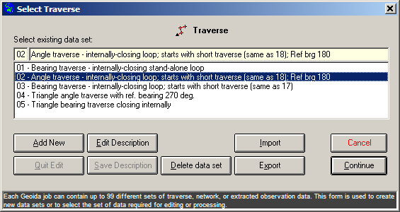
1. Select Traverse
Upon selection of the Traverse option, the following Select Traverse window is displayed whereby a new set of traverse data may be defined and described, or an existing set may be selected.
|
|
More Info: |
When Geoida is running, details of the purpose and use of each control in this window will be displayed in the bottom panel when the mouse is passed over any active object. |
If no data has been entered previously in this option for the
current job or if the Add New button is clicked, Enter
new data set description is shown above the empty
description field. Enter a suitable description for the traverse
set for which observation data is about to be entered and press
Save Description to store. The description entered will now
be added and selected in the list below.
To proceed to manually enter the observation data, click Continue.
If data has been previously entered for the current job, a list of traverse descriptions will be displayed - select any set required for editing or processing and click Continue.
Import and Export - Pre-recorded observation data may be directly loaded into either a newly-created traverse set or appended to an existing set; select the required set from the list and click Import to begin. Observation data may also be exported from any set in the list - select the required data set and click the Export button. Refer to Import and Export Formats for more information about the formats available for import and export.
2. Traverse Entry
The Traverse Entry window is displayed when this option is started and the required data set to process has been selected (see above).
|
|
More Info: |
When Geoida is running, details of the purpose and use of each control in this window will be displayed in the bottom panel when the mouse is passed over any active object. |
The Traverse Parameters header section can only be accessed
on Page 1 - this is because these parameters must only be specified
once for any particular traverse. Although the header is displayed
on subsequent pages, the entered values and settings cannot be
changed.
For simple traverses to be computed with the None or Bowditch adjustment options, both HA and Dist values are required as a complete observation for a point position to be computed. However, observations do not need to be entered in a complete form (i.e. with both HA and Dist fields occupied) but angle/bearing and distance components may be entered into separate records. If incomplete observations are entered, for example a horizontal angle without a distance, Geoida will search all observations to attempt to locate another matching observation over the same line to combine with the first observation to make it complete. If a height-difference component is also found for the line, it is included to allow heights to be carried forward. Horizontal bearing observations are indicated by leaving the From field blank (no backsight or reference point is given) and horizontal angles are indicated by including a point number in the From field.
| IMPORTANT - A single traverse section must consist entirely of either horizontal angle observations or bearing observations (in combination with distances, vertical angles, etc) - there cannot be a mixture of horizontal angles and bearings in the same traverse section. |
For horizontal networks to be adjusted with the LS_Network adjustment options, distance or vertical observations do not have to be combined with horizontal angle or bearing observations such that individual angle-only, bearing-only, distance-only or VC-only observations may be entered. I.e., …
All fields associated with a single record (i.e. comprising the 3 rows of fields grouped together in one panel) may be left blank if necessary. See also the discussion under the heading Incomplete observations below.
The provision of the ToRL field enables the spirit-levelled height values for the observed traverse points to be input through this option without the necessity to go to a separate option - these values have precedence over any calculated height for any observed point. In the case of multiple observations to any particular point, it is only necessary to enter the height value (where available) for the first observation to each point.
| CAUTION - Where data is entered for multiple observations made to each point observed at any one instrument station, if the fields for HA, Dist, VC and VA are filled in one record, they must also be filled for all records for observations between these same points. Only the ToRL, HI, HP and Desc fields may be left blank for all observations within a set following the first observation - in the cases of these particular fields, only the value entered for the first observation is significant, whereas all following are ignored - if the first of any of these fields is blank, any following fields, even if containing data, will be ignored. Where there are multiple observations to a given point from the same instrument station, the type of observation (i.e. the combination of the various data fields in use) MUST NOT VARY - i.e. if one observation is entered as a slope distance/vertical angle type, and another at the same station is a horizontal distance/vertical component type, then an erroneous averaging of the two observations will result. Similarly, where there are forward and reverse distance measurements over the same line, the observation types must match. Failure to observe this principle may lead to unpredictable and entirely erroneous results. (In normal circumstances, these conditions should not arise). |
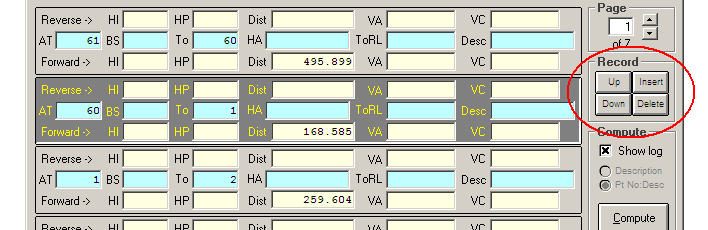
Observation records may be rearranged, inserted or deleted by using
the buttons provided. The buttons operate on the current record
which is indicated by the shaded background.
|
Sections
|
Interpretation of data
Entered observation data is interpreted on the following basis:
When RL's are entered …
When RL's are not entered …
| Important note - Entry of a height
value when both VA and VC fields are blank If a traverse is entered in the simple form of angles-turned and horizontal distances only, with no vertical data, other than an occasional spirit-levelled height, a potentially serious source of error will arise for those points that have heights entered in the ToRL field unless a VC value is also entered - this is because the distance will be interpreted as a slope distance when there is a height value available but no VC value. The program checks for this condition, and if the data consists of the two conflicting types of observation, a warning message will be displayed, followed by the prompt Continue reduction ? If the data is known to be correct, the processing may be continued by answering 'Yes', otherwise the reduction will stop and return to the menu. A VC value of zero (0.000) may be entered to prevent each horizontal distance accompanied by a height value for the forward point, being read as a slope distance. |
Incomplete observations
Where a reverse distance has been measured over the last line in a traverse but no forward point was observed, enter the observation as normal but enter the backsight point number as the observed point number in the To field, enter 0.0000 for the horizontal angle, and -999.999 as the forward distance. When a closure has been made onto a fixed point and a final angle was turned onto a second fixed point but no forward distance was measured, enter -999.999 for the distance.
Meaning and sorting of traverse observations
When to mean or not mean observations - The following guidelines will help decide when to apply meaning to the traverse observations entered via the Traverse option ...
Mean Control Observations CROSSED - Depending on the format of the observations (for example repeated observations along the same lines from one or more instrument stations), the enabling of observation meaning (or balancing in the case of vertical angles and distances) will be best suited to simple traversing with the None or Bowditch adjustment modes, and for the subsequent editing of the Extract data into a continuous and sequential traverse route which may also be used for the provisional coordination of points to be later adjusted using the LS Network mode. This setting is generally NOT recommended for a least squares adjustment unless (eg) distances are to be meaned to eliminate the curvature-refraction correction - i.e., it may be suitable for least squares when only single angle observations have been made but both forward and reverse distances were observed.
Mean Control Observations UNcrossed - This setting is the recommended setting for a LS Network adjustment - no meaning of angles or balancing of distances will take place and all observations will be written to the Extract file as they have been entered (and with distances reduced to horizontal and datum). This is not recommended for a normal traverse (None or Bowditch adjustment modes) since if the data consists of multiple angle or distance observations over the same lines, a simple consecutive observation sequence suitable for traverse reduction may not result - reduction of such a set of data may be difficult and require extensive prior editing of the Extract file with subsequent processing in the Process Extracted Observations option.
Recommendation - CROSS the Mean Control Observations check-box to process a traverse route for the computation of provisional points for a least squares adjustment - note that it may still be necessary to edit the Extract file created by this step and process it in the Process Extracted Observations option. When the provisional points have been computed, re-run the Traverse option with Mean Control Observations UNcrossed and LS Network mode selected - note that it may still be necessary to again edit this newest Extract file and reprocess the edited set of observations using the Process Extracted Observations option set for a LS Network adjustment.
Refer also the section Meaning, sorting and correction of control, traverse and network observations in the Extract file topic.
Processing traverse
The Compute button is not enabled until sufficient details or data have been entered,.
When meaning traverse observations and an observation is encountered which has a blank height value for the point (eg a reverse-distance observation to the previous traverse station), the program searches back through the preceding observations for an observation to the same point; if this observation has a height value specified for the given point, that value is inserted into the current observation. Thus if slope distances were entered (and VA is not equivalent to 90 degrees zenith), the horizontal distance is reduced from point heights and not from the given vertical angle; in this case, the computed VC is ignored and the given height is entered into the database as the height value for the point.
Refer to Survey Data
Processing for a list of topics with further general
information and to Traverse and Network
Processing for information specific to the traverse data
reduction procedure.
| Converted from CHM to HTML with chm2web Standard 2.85 (unicode) |