
Geoida
Help
|
|
Geoida |
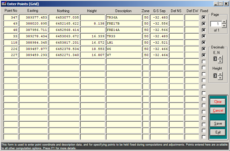
Enter Points |
Before any computations may be made (except in the case of the reduction of total station data where coordinate values for control points may have been included in the data), the coordinates for control points, and in the case of traverse or network reduction, points to be held fixed, will usually be entered and stored in the database through this option. Points may also be entered individually using the Digitise Provisional Points option, or imported using the Import option.
There are two Enter Points options - these options permit points to be defined with either grid or geographic coordinates in the same job but are otherwise identical:
Note: The point coordinates stored in the job database will be converted to the coordinate type defined for the job in Job Configuration regardless of the Enter Points option used
The Enter Points window is displayed when this option is selected.
|
|
More Info: |
When Geoida is running, details of the purpose and use of each control in this window will be displayed in the bottom panel when the mouse is passed over any active object. |
Upon selecting Exit to return to the main menu, the prompt Write points to database and assign fixed points (if any) is displayed. Select Yes to store the points entered and assign any fixed points. Select No to skip this stage, in which case points that may have been previously re-valued by some other option will not be replaced with the values entered in Enter Points, but note that any changes made to the Enter Points data are still retained and saved.
Points to be held fixed during traverse or network adjustment are specified in the Enter Points window and are read whenever the traverse or network adjustment is run.
Points are normally set fixed when entering coordinate values for control points. However, in cases where points have been or will be computed by some other means, or their values will be read directly from a total station data file, points to be held fixed may be specified by point number only, leaving the easting and northing (and other) fields blank.
For fixed points required for a level network adjustment where the horizontal position is not known or not important, the heights can be entered but the easting and northing fields can be left blank as above. These points will be written to the points database because the height values are required for computation, but the easting and northing values will be assigned null values.
Fixed points will generally be survey control points; do not fix traverse or network points that require adjustment. Database values can never be overwritten by any Survey menu option while a point is specified as fixed. If a point is computed but is already defined as a fixed point, the message Point xx is fixed and the point's stored and computed coordinate values are written to the LOG file, but the stored database values will not be altered. If no values have been previously stored for the point which has been defined as fixed, the user will be prompted to enter the point details which will be stored instead of the calculated values.
Note : setting points fixed does not prevent them from being deleted in Delete Points if Delete fixed points is selected.
| Converted from CHM to HTML with chm2web Standard 2.85 (unicode) |