
Geoida
Help
|
|
Geoida |
Survey Options - General Notes |
This section deals with issues common to all or most of the data processing options in the Survey Menu.
Sections
|
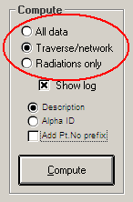
Traverse/network or Radiations mode
If the data contains both control survey, and detail pick-up observed as radiations from stations coordinated (and adjusted) on the control survey, it is usually preferable to first process the control survey only (i.e. with the Traverse/network radio button selected). This is so that the control stage can be completed satisfactorily before computing radiations based upon the control points - obviously it would be superfluous to compute radiations from traverse or network points if these have to be later adjusted, since this would then require a re-computation of the radiated points. Or, in the case when a traverse route has also been spirit-levelled, the heights of the traverse points could be modified to the spirit-levelled values (eg, using the Interrogate Point option to individually edit each point) following horizontal adjustment so that radiated points subsequently computed would also have correct heights.
|
Following the processing of traverse or network data, the same option may then be re-run with the Radiations Only radio button selected to compute the radiated points.
If the compute mode is set to All data, any control traverse or network observations will be detected first, written to an Extract file, then reduced and adjusted. The option will then go back to find and reduce any radiations and will compute these using instrument stations on the traverse or network previously adjusted.
When a traverse/network adjustment is performed, points that already existed will be re-computed (unless they were set as 'fixed'). Points computed as radiations are NOT over-written if they already exist - this protects any previously adjusted traverse or network points from being over-written. If radiation points exist from a previous computation and must be updated, they must be deleted first before re-computing. When processing is finished, a message will be displayed to advise the numbers of computed points. (See also Existing points not over-written later in this topic).
Control points and reference bearings
To commence a radiations or traverse computation, when re-starting in a new traverse section, when computing a forward bearing at any setup, or closing off a traverse onto fixed control points, Geoida will require at least one control point (the current instrument station), and either another control point from which to compute a reference bearing (the 'RO' or backsight/foresight point) or the actual reference bearing. If the named control point is not found in the database or has not been set 'Fixed', a prompt similar to the following may be displayed (eg):
| Backsight point 103 has not been specified as Fixed (does not exist) Do you wish to specify fixed points now ? (To specify a Reference Bearing, answer 'No') |
In response to this prompt, choose YES or NO as follows:
Note that if the Enter Points window is displayed at one
of these prompts, any other non-existing points that may also be
required or points whose details require modifying, may also be
entered at this stage.
Total Station derived data
The following comments relate to the processing of data derived either directly from a Total Station (as in the case of a Sokkia SDR or TDS/Carlson RW5 data file) or a file of data translated from a similar source (such as a CDS Stadia or Civilcad Neutral file).
Points read from file
If the data file contains point coordinate records, the points will be written to the job database if they do not already exist, but if points do already exist, they will NOT be over-written and the LOG file will contain a note to that effect. If it is desired to replace any points previously existing in the database with those read from the data file, it will be first necessary to delete the points before processing the data file.
Processing control survey data
The aim is to extract all control survey observations and write them to an Extract file for further processing.
Initially all observations are read from the data file. Simple radiations are eliminated by searching forward to find a re-occurrence of each point number. If the number re-occurs later in the file, the point is assumed to be NOT a simple radiated pick-up point (eg, an observation to a prism on a pole), but may instead be a point used elsewhere as a backsight, an instrument setup or for a resection, or is a two-face observation to (presumably) a prism on a tripod and will need to be meaned.
The number of simple radiated observations excluded from the data by this process will be noted in the LOG file and observations determined to be valid traverse or network observations will be listed. Any empty records or other records deemed to be of no value or superfluous will be deleted.
Observation types - Observations in a data file derived either directly from a Total Station (eg Sokkia SDR or Carlson RW5 data file) or from a file of translated data (eg CDS Stadia or Civilcad Neutral file) may be interpreted by Geoida as two types:
.PNG)
|
.PNG)
|
Examination of the LOG file will reveal that setup/backsight records are generally marked 'T' for type-1 observations, and 'S' for type-2 observations as follows:
All observations following a setup/backsight record are marked 'O' until the next setup/backsight record occurs - the observation types are indicated only in the LOG file and are not shown in the Extract file.
Where it is able to distinguish them, Geoida retains the distinction between these observation types and does not mix them during the meaning process. If observations to a certain point occur as both types at the same setup, the type-2 observations are discarded as they are assumed to be the raw observations subsequently corrected and meaned in the set of type-1 observations. If there are any observations thereafter remaining at any setup that occur as raw observations only, these observations are retained and, if there are any Face1/Face2 observations, these are meaned also.
Note that repeated raw observations on a single face to the same point ARE NOT MEANED due to the greater difficulty and uncertainty of determining if the repetition method of observing horizontal angles has been used. If such observations have been made, only the first observation to any particular point will be retained. If it is necessary to use a meaned observation in each case, it will be necessary for the user to edit the Extract file and modify each of these observations to a manually-determined meaned value. Then reprocess the Extract file in the Process Extracted Observations option - the setting for the Mean Control Observations check-box would be of no account at this stage if no other changes were made.
Differences when processing e-Data files
When reading control survey observation data from an SDR data file, the Geoida e-Data option reads observations in one or two steps depending on the type of observations recorded. In the first step, Geoida searches for only 'Meaned and Corrected' (MC) observation sets preceded by a 'Set' record (type code 12) and writes these to an Extract file. However, if no MC observation sets are found, it re-reads the file as the second step reading all raw observations, and then analyses the observations as for type-2 observations above - any traverse or control observations thus detected are then written to an Extract file for traverse or network processing.
TDS or Carlson RW5 data files are treated similarly to a Sokkia SDR file except that in the first step Geoida searches for observation sets defined by BD/BR and FD/FR records; if no sets are found in the file it is re-read in a second pass to search for type-2 observations recorded as TR (TRaverse) records.
The software applications CDS and Civilcad read all observations and both raw observations and meaned/corrected sets will be written to the Stadia and Neutral files. In the CDS Stadia file, a field note with the value "SET" is written preceding each set, but Civilcad makes no particular distinction between the raw observations and the set unless a suitable note was already present in the raw data and is repeated in the Neutral file. Therefore it may not always be possible for Geoida to distinguish between the two types and there is the risk that raw observations could be incorrectly meaned with already-meaned and corrected observations.
If necessary, the user can eliminate unnecessary raw observations from the Geoida Standard Extract file by manual editing. In the CDS Stadia and Civilcad Neutral options, Geoida discards raw observations if meaned and corrected observations have also been recorded and can be detected or if the raw observations are single shots only. Any point observed more than once or used also for an instrument station or RO will be taken to be a traverse or control observation and will therefore be included in the Extract file.
Where a point has been observed a number of times at a setup and is therefore included in the Extract file, it is possible that it may still be only a radiated point which does not constitute an essential leg of a traverse or network. The presence of an excessive number of such observations could either overload a least squares adjustment with excessive unknowns and/or cause a very poor adjustment with large residuals and outliers, and should therefore be eliminated from the Extract file by manual editing before the final adjustment.
The risk of including unwanted raw observations or non-control radiation shots is not a factor when directly processing original data-recorder files such as Sokkia SDR or Carlson RW5 with the e-Data option but may occur with translated CDS Stadia and Civilcad Neutral files. The elimination of an unwanted raw observation from data derived from stadia or neutral data is achieved subject to the following conditions:
An unwanted raw observation is eliminated if:
but will otherwise be retained if
Rounding - Geoida retains the full precision of angle values
as recorded in a data file. However when translating a raw data
file, CDS and Civilcad round angles to the nearest whole second
which will result in some differences being apparent between the
different methods of data processing if comparisons are made.
Rounding may also be noticed when the same observation data is
exported in different formats from the same data recorder.
| IMPORTANT FURTHER DETAILS on traverse and network reduction are covered in General Principles for Traverse Processing. |
Existing points not over-written
Survey menu options which process data as radiation observations will not over-write points that already exist in the database. The main reason for this is that points observed by radiation may actually be check-shots to points on the control survey that have been previously adjusted or other control points which must obviously remain un-changed, so this feature protects those previously-derived points from accidental change. Therefore, previously computed radiated points must be first deleted from the database before they can be re-computed. When computing radiations Geoida will not over-write existing points, and when all data has been processed will display (eg) …
| 306 points were computed including 18 traverse/network
points but only 18 were stored. This may be because radiated points had already been computed. (Refer to details of log file for more information) If you require RADIATED points to be added to the database, they must first be deleted (if they exist) before computing. |
This applies only for radiations, not for control-type observations - this is to protect original coordinates in cases where an original (or previously-surveyed) point has been re-observed, for example, as a check shot.
Assessing incorrect results
If, after a first reduction run, computed values appear to be incorrect, the reduction log (file jobname.LOG) will usually be of assistance in locating problems.
The following points may also assist in locating a problem :
Remember that if radiation data is to be reduced a second time (for example, after correcting errors in the data file), then the points that are to be re-valued must be first deleted from the database as they will not otherwise be over-written. The message
| Point .. not over-written - old values still exist |
will be shown in the LOG file when radiation points have been re-calculated but have not been added to the database because they already existed. However, traverse and network points are over-written by a subsequent reduction involving the same points and old values do not need to be deleted from the database beforehand; fixed points are never over-written.
Tolerance checking
During normal data reduction (i.e., not Least Squares Network adjustments) computed points are compared to any previously-existing values to aid the detection of gross observation or data entry errors. The differences between the computed and existing coordinates are recorded in the LOG file for every point. If the differences exceed the tolerance (twice 5th-order = 200 x (Km + 0.2) or approximately 1:5000), a note is printed in the LOG file and a message advising the total number of failures will be displayed when processing has concluded and prior to the display of the LOG file.
The LOG file notation of a discrepancy in the horizontal position of a traverse point will be similar to:
Point calc'd:  1786   971.975 E  5024.971 N  102.016 Ht
Existing Point 1786: 1002.248 E  5002.387 N  102.013 Ht
    Difference :   -30.273 East  22.584 North  0.003 Ht  - CHECK MISCLOSE: 7.769 at 306°43'25"
|
The notation of a discrepancy in the vertical position of a radiated point will be similar to:
Point calc'd:  1643  1000.002 E  5028.146 N  100.019 Ht
Point 1643 not over-written - old values retained
Existing Point 1643: 1000.000 E  5028.147 N  0.000 Ht
    Difference :   0.002 East  -0.001 North   100.019 Ht  - CHECK HEIGHT MISCLOSE: 100.019
|
| Converted from CHM to HTML with chm2web Standard 2.85 (unicode) |