
Geoida
Help
|
|
Geoida |
Form TIN Geoid Model |
Form TIN Geoid Model creates a Trianglated Irregular Network (TIN) model of the geoid-spheroid separations (N) and vertical deflections of all fixed points. From this model, geoid values may be interpolated during data processing to reduce observations to the spheroid or to correct angle observations for deflection due to gravity, or they may be extracted for reporting and data-listing purposes.
This option is enabled only for those jobs defined in Job Configuration as follows …
Note: The geoid model network cannot be displayed if the coordinate display is set to Geographic - in the View menu, the Plot Geographic option, and the Geoid model checkbox in Display Settings, will be disabled when the display is in geographic mode.
Where it is required to compute projection or geographic coordinates for observed points, the field observations must be reduced to the projection datum, and if the height components are related to a geoidal (or spirit levelled) vertical datum, then it will normally be necessary to correct for the geoid-spheroid separation to maintain correctness and accuracy.
To achieve these requirements, the Geoida job must be configured with a spheroidal horizontal datum, a geoidal / orthometric vertical datum, and the Apply to obs check box in Job Configuration must be crossed in order to incorporate into the reductions, geoid-spheroid separations as interpolated from a geoid model.
However, where height components are related instead to a vertical datum based on the spheroid rather than the geoid, it is not necessary to make any correction for separation, and the Apply to obs check box in Job Configuration should be uncrossed. However, it may still be desirable to interpolate geoid values for reporting or listing purposes in such a case, so a geoid model may still be formed for that purpose and provided that Apply to obs is not crossed, geoid values will not be incorporated into observation reductions.
Setting up the model - At least three fixed points with
pre-set undulation or deflection values are required before this
option can compute a geoid model - unfixed points are not
used even though they may have geoid values assigned either
manually or by prior interpolation. Prior to processing of
observations, a certain number of control points of known value
must be set fixed as a reference frame for the coordination and
adjustment of new points. If these are permanent bench marks,
standard survey marks or other officially-established and
controlled points, their correct geoid values will normally be
shown on their summary sheets. Therefore all points for which known
values are available can be set as fixed prior to running this
option so that a geoid model is formed entirely from points with
known values. Following formation of the model, other control
points whose geoid values were unknown and were previously set
unfixed to prevent their inclusion in the model, may now be set
fixed again for normal data processing and adjustments.
|
CAUTION |
Summary sheets will often show horizontal and vertical details for more than one datum and spheroid. It is vital that the values for the correct datum and spheroid be used or errors will result. |
Points may be set fixed either in Enter Points, with the Modify function in List Points / Export, or by Interrogate Point.
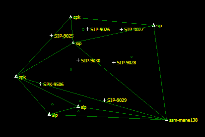
When formation of the model has concluded, the triangular mesh for the model will be displayed - this may be turned off if not required by un-checking the Geoid model checkbox in Display Settings.
|
|
Figure 1: Fixed-point TIN -
The triangular mesh of the three-dimensional geoid model created by
the Points menu Form
TIN Geoid Model option. Each triangle represents a flat
plane between the three apex points where the centroid of each
triangle is marked with 'o'
|
| WARNING - Fixed points have been modified since the
geoid model was formed !! If the Geoid-ellipsoid Separation or Deflection values were included in the changes, you should re-form the model before proceeding to avoid interpolation errors with un-fixed points. |
and, depending on the option executed, may also prompt Do you wish to continue ? If the geoid values for a fixed point were changed to correct a previous mistake, then the geoid model should be reformed prior to any further computations so that subsequent interpolations on the model will be correct.
Points falling outside the model - The fixed points selected
for forming the model may not adequately cover the job area. If
other known points occur nearby, these may be added to the job and
set fixed for inclusion in the model so that it will cover a larger
extent and hopefully include all observed points, even though these
additional known points may not be used as control for the job.
However if this is not possible and points still fall outside the
model, Geoida will extrapolate geoid values for these points
by extending the plane of the most appropriate adjacent triangle to
that position. Extrapolation reduces the reliability of the
resulting interpolated values and should be treated with caution at
unreasonable distances from the edges of the model.
Other geoid models - The Form TIN Geoid Model option forms a
triangular mesh from irregularly positioned fixed points. This is
in contrast to models such as the Australian AUSgeoid98
model for which geoid values at the nodes of a regular 2-minute
geographic grid are published and are readily available. To
interpolate geoid values using such a model, the Interpolation
Method in Job Configuration must be set to Bi-cubic
lat/long grid or Bilinear lat/long grid.
Grid geoid models are suitable for areas of large extent and (in the case of eg, AUSgeoid98) may be less likely to suffer the problem of points falling outside the model coverage because the data is available for all of the Australian map grid area. TIN models may be more suitable for smaller project areas where a closer network of known points occurs but may also be useful where a large number of known points occur over an extensive area.
Refer to Job Configuration for discussion of the different interpolation methods, and to Geoid-Spheroid Separation for more general information regarding geoid-spheroid separation.
| Converted from CHM to HTML with chm2web Standard 2.85 (unicode) |